A trip to Papa Stour with Simmer Dim Charters

Papa Stour’s west coast
For many people visiting Shetland, a trip to one or more of the outer isles is always on the itinerary, and in Shetland, visitors are spoilt for choice. With 16 inhabited islands, 15 of them available to visit – nine by inter-island ferry – it can be tricky to pick which one to explore.
This week, I will show you why you should visit one of the lesser-explored islands. This blog focuses on Papa Stour, with Simmer Dim Charters.
Papa Stour, known simply as ‘Papa’, sits a mile off Shetland’s west coast, and Simmer Dim Charters run tours to the island. The 10-metre boat, Wilma Jane, has an open deck – perfect for viewing the tantalising west coast landscape or fishing – and a spacious cabin to relax in and pour through information about the islands. The boat is licensed to carry eight passengers, and bookings can be made in advance by emailing John Anderson at johnpund@btopenworld.com.


As well as Papa, Simmer Dim Charters offers angling and shorter sightseeing trips around St Magnus Bay, including Muckle Roe and Eshaness.
Skipper, John, has so many fascinating stories about Papa. As we approached the island, he told me about a young woman whose protective father sent her to live in a stone hut on top of a sheer-faced sea stack to keep her away from potential suitors. A local man, determined to seduce her, climbed the stack, and nine months later, just like clockwork, a baby was born.

The Maiden Stack (or Frau Stack), believed to be where a young woman was sent to live.
John’s stories bring this rugged, sea-ravaged coastline to life in amazing technicolour; with stories of shipwrecks, survival and local lore – he brings to life the people who once populated these now-small communities.
The island’s name comes from the Old Norse language, meaning “the great island of the priests”, and the scattered remains of past people dominate the landscape. The island is geologically fascinating, formed from volcanic ash and lava, a real gift to hikers seeking the drama, allure and breathtaking vistas offered by this incredible coastline.


This fertile and lush island had a peak population of 382 in 1841, but since the 1870s, this has declined steadily. Today, it is accessible several times a week by ferry from West Burrafirth – or, as we did, by a dedicated boat trip to maximise our time (from Aith or West Burrafirth).
The handful of permanent residents no longer have a school or shop, and there are few facilities on the island for visitors beyond the ferry waiting room (though the deconsecrated church is currently undergoing redevelopment into a heritage centre for visitors).
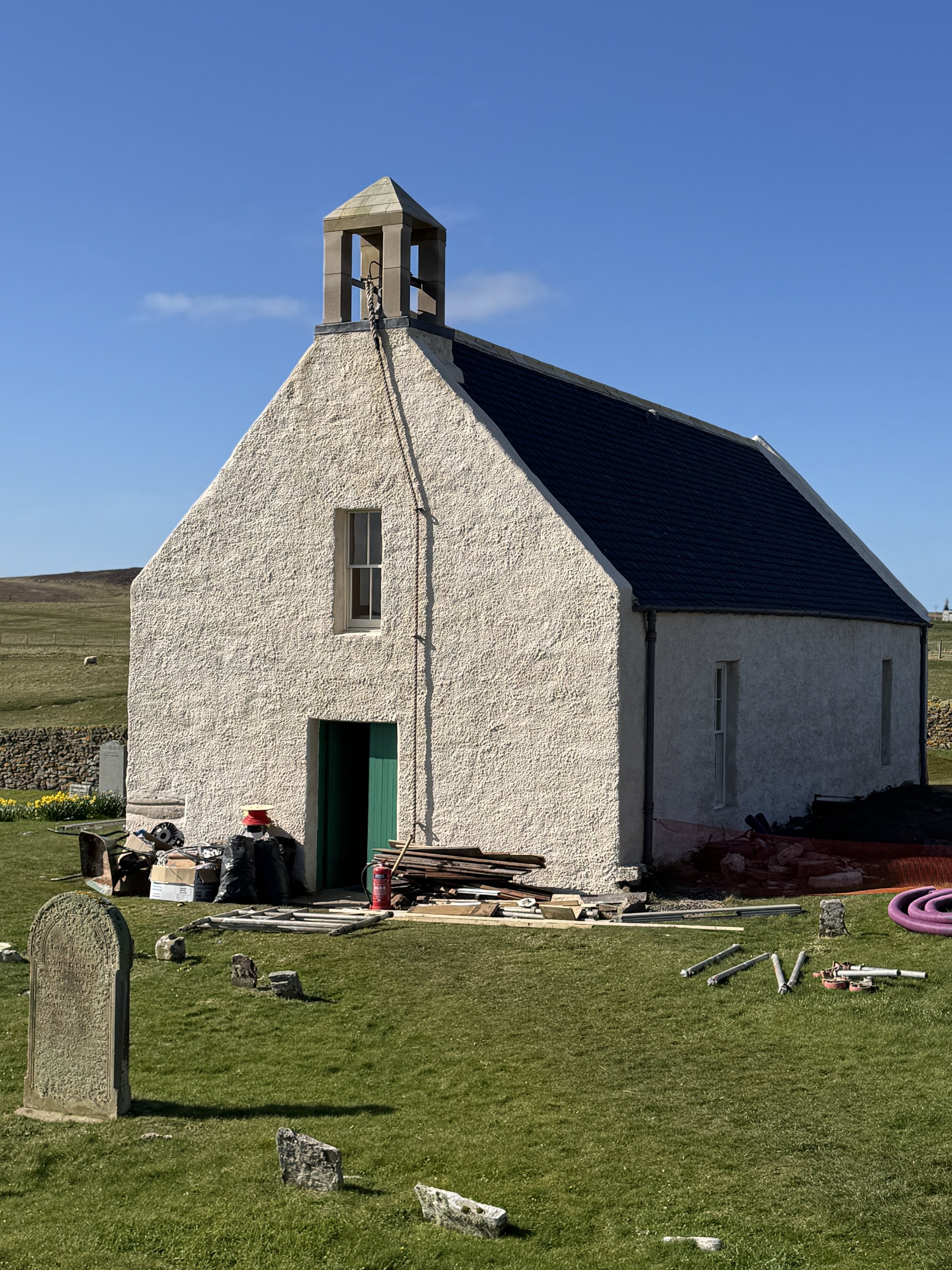
Papa Kirk is undergoing renovations at the moment (2025)
Despite this, Papa is an island that calls to be explored, offering endless hours of enjoyment along its rugged coastline – just remember to pack a hearty picnic and a sense of adventure!
Papa is best explored on foot – its extraordinary coastline is marked by caves, geos, gloups (sea caves where the landward end has collapsed), arches, boulder beaches, and stacks formed by volcanic rock and ash and eroded over millennia by the unrelenting Atlantic Ocean.
Papa is wildlife-rich, with summer colonies of Arctic terns and great skuas that take to the air and dominate the boulder beaches and moorlands in the west of the island. (If walking while they are nesting, give them a wide berth to avoid disturbing their nests.)
The shoreline is an excellent place to see seals or otters, and whales frequently pass around the island. Throughout the summer, wildflowers add a vibrant splash of colour to the landscape, particularly on the cliff tops with their candyfloss-pink thrift and rich blue squill contrasting with the red granite rock below.
We landed at the pier at Housa Voe, and John walked us along the mile or so of tarred road towards the disused airstrip, pointing out the houses as we went. I have Papa connections; my great-great grandparents on my mother’s side came from Papa in the late 19th century. George Johnson, my great-great-grandfather was born at Olligarth, and my great-great-grandmother, Eliza Fraser, came from the East Biggins – which is now an AirBnB (I’ve made a mental note to go and stay there!).


Want more from Shetland? Pick up a copy of my Guidebook today.
Discover hidden gems and rich history with our guidebook. Navigate like a local to find the best scenic spots, and cultural highlights. Our maps, itineraries, recommendations, and tips ensure you make the most of your time, whether you're a first-time visitor or returning. Purchase our guidebook today for a memorable journey. Your perfect trip starts here.
Once we got to the “hill daek”, where the cultivated “infields” gave way to the open moorland used as communal grazing for sheep, John waved us on our way towards the island’s west coast.
Setting off over the former runway, we joined the remains of several “meal roads” towards Hamna Voe. These roads were constructed throughout the Highlands and Islands in the 19th century, with the first being commissioned in the 1840s. Known as the Hungry 40s, this period was characterised by crop failures that led to famine throughout Shetland and the wider Highlands and Islands region. As a result, authorities ordered the building of roads, and workers were paid in oatmeal or flour, known as meal.

Meal Road in Papa.
The old road led us down to the enclosed bay of Hamna Voe, which was once an important trading area where Dutch traders landed goods. The nearby Dutch Loch takes its name from this trade, and several traditional horizontal watermills or “click” mills stand in ruin along the burn, fed from the loch.
For hikers, the coastline between Hamna Voe and Virda Field (87m/285ft), on the island’s west coast, is one of the best in Shetland, and from Virda Field, you have a panoramic view of the island.
We walked 8 miles around the dramatic west coast, including Kirstan’s Hole – and the ‘new’ hole (these are basically two holes in the ground where the inland end of a sea cave has collapsed, allowing you to see the sea washing in from above) – and Aesha Head where we enjoyed views of Aesha Stack, Sula Stack, Fogla and Lyra Skerry, and on towards Virda Field. It was a glorious spring day – perfect for walking – and the sky wore her best blue guise, contrasting beautifully with the inky blue sea and rich-red granite cliffs that dominate the island’s west.


With time ticking away and feeling like we could stay forever, we turned tail and headed back towards the airstrip, where we rejoined the road and headed back to John, who was waiting at the boat with steaming mugs of coffee.
And, just like that, Arnold slipped the ropes as John steered Wilma Jane back towards the mainland, and our fabulous day was over.

Sitting gazing over the stern of the boat, I watched the sun kiss the hills of Foula, bathing its jagged peaks in a golden glow, as Papa melted into the horizon. It was one of those rare, reflective moments – the kind that tugs away at something deep inside you. Papa is an island steeped in history, with many stories left untold. John’s passion for this island reminded me that Shetlanders never let their stories go, and, in a world that often feels determined to tear itself apart, John’s connection to this place and its people was a huge comfort.
With windburned cheeks that glowed against the gathering dusk, aching legs, and a full heart, I stepped off the boat feeling both nostalgic and renewed, and more than ready to take on the next week – our Sunday in Papa with Simmer Dim Charters was the medicine I never knew I needed.

Ways you can support my work…

