
A winter walk around St Ninian’s Isle

It’s not often that January brings prolonged periods of still and frosty weather, but that’s exactly what we had here throughout January and, as we battle with homeschooling and the ever-present threat of cabin fever, it’s definitely nice to get out into the fresh air for a few hours.
We recently walked around St Ninian’s Isle and, as well as being great for adults, this walk is also fantastic for anyone with children. It’s not always easy to persuade bairns to go on a hike, but this one is perfect as there’s a beach, plenty of wildlife and the promise of buried treasure at the end to keep them engaged.
Similarly, this is a walk that is just as rewarding in all seasons. I have highlighted it in winter because, unlike some other walks that can be too wet and boggy at this time of year, this walk is still relatively dry in winter (although you will need walking boots).
This is also a walk that I often do on tours of the South Mainland as the walk and distance can be adapted to suit everyone’s mobility. If you book a tour with me and want to do all or part of this walk, we can discuss that.

Today we did a shortened version of the island circular. We were away for two hours and covered two miles, and our pace was slow and included time to stop for a picnic and play on the beach. Two hours would allow enough time to walk the whole island (we were slow as I had the children).
For the walk, park at the beach at St Ninian’s Isle and make your way across the sand tombolo towards the island. There’s an obvious sandy road onto the island rutted by tractor tyres. Follow this road up the hill before veering off to the left.

Along the way, you may notice the old well, known as the Holy Well, fed with crystal clear water from a spring below. Make your way towards the cliffs on the south-west corner of the isle.
As you walk, notice the large drystone wall on the horizon to your right – this was built using stone from houses that once stood on the isle. St Ninian’s Isle was inhabited by several families until 1790 when the islanders ran out of peat and moved to the Mainland. I like walking in the winter because the combination of the low sun and the parched grass clearly shows the evidence where people once worked the land. Scan the landscape and pick out the silhouettes of where rigs and fields were once cultivated.
Standing on the south-west corner of the island, looking south towards Fitful Head affords stunning views. The rugged coastline is almost unexpected after the sweeping sands of the tombolo where we’ve come from. It’s important to remember that we are on the exposed Atlantic coast, and much of this coastline is dramatic and sheer.

Please take a moment to look around at how the rocks were formed, the lines on the cliffs and outlying rocks show how they were forced from the earth under extreme pressure. Like much of the South Mainland, this area lies on a bed of Old Red Sandstone and belongs to the Dalradian Supergroup, dating between 730-580 mya.


From here, head west following the rough grass path towards the access stile. Following the coast around to the back of the isle and its western extremity, you come to Hich (High) Holm, a small island, known as a holm, off the coast of St Ninian’s Isle. In the summer, this is an important breeding ground for Kittiwakes, a seabird whose numbers have been in sharp decline over the past few decades.
Beyond Hich Holm, Foula dominates the western horizon. Foula is our most westerly island, about 24 miles west of the Mainland and home to about 30 people. Foula’s peaks loom on the horizon like mountains.

From here, continue to follow the coast north until you reach Selchie Geo. This is an incredible place to watch Maalies (fulmars) as they play in the thermals. When we were there, there were hundreds of these birds. Interestingly, fulmars were only introduced to Shetland in the late 19th century and, today, they are our most abundant seabird.
Watch out for seals in the bay because, as the name suggests (Selchie Geo), you may see a selkie (seal).


By now, and after a pit stop for a picnic, my little legs were beginning to protest. This is the perfect place to cut the walk short and head back towards the beach. We sliced the island in two, heading east following the sheep gaet [path] towards the drystone wall’s access gate. This route will take you directly to the Chapel site.
However, you can carry on around the north end of the isle, rounding the alarmingly named Loose Head. Loose Head is the highest point of the island, and you’ll find a Trig point to mark this. Trig points are triangulation pillars used for surveying. They are seen dotted across Shetland, and the UK, and were devised by Brig Martin Hotine to provide a solid base for theodolites. The Ordnance Survey used trig points to map Britain from 1936, and there are 143 in Shetland.

Walking back towards the tombolo of St Ninian’s from Loose Head allows for beautiful views of the beach and across to Ireland and Bigton on the Mainland. One of my favourite spots along the way is the giant erratic, deposited during the Ice Age (c. 10,000 years ago) and made of striking white quartz. This stands out in the landscape like a glittering beacon, just asking for a staged photo – so strike a pose!
St Ninian’s Isle and the surrounding bays have seen several shipwrecks, including The Atlas, the “Shugger Ship” (Gesina), The Earl Spencer and the Christiana.
All these ships tell an interesting story, and their tales are woven into local lore. I had the pleasure of joining local man and guide, James Tait, on a walk around the island, and he regaled these stories to me. The stories are fantastic, and James (and myself) offers tours of the island where you can hear more about these. James is the owner of Island Trails, and his guided island walks are a treat!

St Ninian's Isle Chapel site
No matter whether you took the shortcut or went the long way around Loose Head, we are now at the Medieval Chapel site looking back across the tombolo towards the mainland. (You can also skip the walk entirely and head straight to the Chapel from the beach. This is something we do on tours frequently.)
The Chapel site is easily found as the original church’s ruins are fenced in against the burrowing rabbits, and there are interpretation panels that fully explain the site.
This is the spot where, in 1958, schoolboy Douglas Coutts discovered the St Ninian’s Isle treasure hoard. He had joined a team from the University of Aberdeen on a dig led by Professor O’Dell at the 12th-century chapel site. It was the first day of the summer holidays, and his first day on the dig site. He was sent to a corner of the site, away from the important work of the ‘real archaeologists’. He was handed a trowel – the spade used by archaeologists – and set to work digging.
It wasn’t long before he unearthed a cross-marked slab. When the slab was removed, it revealed a larch box, placed upside down. Inside the box, the excited team discovered one of Scotland’s most significant treasure hoards.

The treasure comprises twenty-eight pieces of highly decorated silverware (the main items are brooches, bowls and pieces of weapons) and a fragment of a porpoise’s jawbone. It is thought that the treasure is Pictish and dates to about AD 800. It was buried in a larch box (a type of tree that did not grow in Scotland or Shetland) and uncovered in the later 12th-century chapel, under the church’s nave. It is generally believed that the treasure was buried below the floor of an earlier chapel.
O’Dell and his team worked on the site between 1955 and 1959. The initial work aimed to examine the medieval church. They had no idea there would be Pictish treasure buried in it.
The treasure, of national importance, is now on display in the National Museum in Edinburgh and replicas can be viewed in the Shetland Museum & Archives.
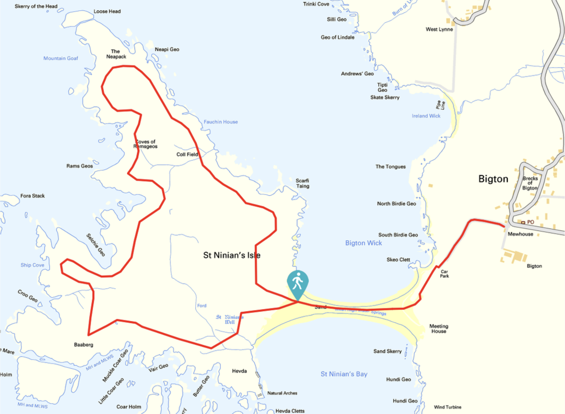
Route map, St Ninian's Isle circular (full walk)

Route map (this is the walk we did)
This walk really does have it all so, when it’s safe to visit Shetland – or if you’re in Shetland already – be sure to visit this fascinating little island and let the sea lick your boots as you walk the long stretch of golden sand towards the island.
Remember to enjoy Shetland responsibly. For more information about following the Outdoor Access Code, please visit this blog.

I hope you enjoyed our walk!