
A guide to walking to the Lang Ayre, Northmavine

If a Munro is a small mountain, then a Marilyn is a small Munro. And a small-small mountain is exactly what we climbed (and some) a few weeks ago. I was invited to join a lovely group of folk on a hike to the Lang Ayre in Northmavine in Shetland’s North Mainland. The Lang Ayre was a bucket list goal of mine, the long walk which takes in the small-small mountain, Ronas Hill – the highest in Shetland – is one that I have been meaning to do for years.

The stunning Lang Ayre in Shetland's North Mainland. Photo courtesy of Southspear Media
It was a beautiful summer day, the kind that remains etched in memory for long after it has passed. And as the group assembled in dribs and drabs at the old NATO station on top of Collafirth Hill, the sun hung high, throwing warm rays over us from a sky that promised nothing but pure unadulterated sunshine. Leaving our convoy of cars and 4G signal behind us, we finally set off into the hill at about midday.

On top of Ronas Hill. Photo courtesy of Kaylee Stevenson
Walk
: Moderately challenging
Distance
: 9 miles
Duration
: We took 6 hours (but spent about an hour or so on the beach and half an hour on top of Ronas Hill)
Total height
: 450 metres

Walking up Ronas Hill, Shetland. Photo courtesy of Southspear Media
The walk is in Northmavine, a landscape characterised by the red granite stone intrusion – or batholith (as I was told) – that makes up this fascinating corner of north-west Shetland. The area is dominated by Ronas Hill (our small-small mountain) that stands proud at 450 metres and often lies cloaked in low cloud and hill fog. But not on the day we visited, the sun shone off the red granite, illuminating the steep slopes and bathing all the miniature Arctic Alpines in light, making them stand from the rough rock like tiny beacons.
Ronas Hill is home to several varieties of Arctic Alpines that have survived here, presumably from before the last Ice Age retreated about 10,000 years ago. Of these miniature marvels, there is Mountain azalea, alpine lady’s mantle and spiked woodrush. These hardy little miniatures are usually only found on high mountains, or in the Arctic, but they thrive here, and as we ascended to the upper heights we spotted all three clinging to the unforgiving slopes of the rocky tundra.

Mountain azalea

Alpine lady's mantle
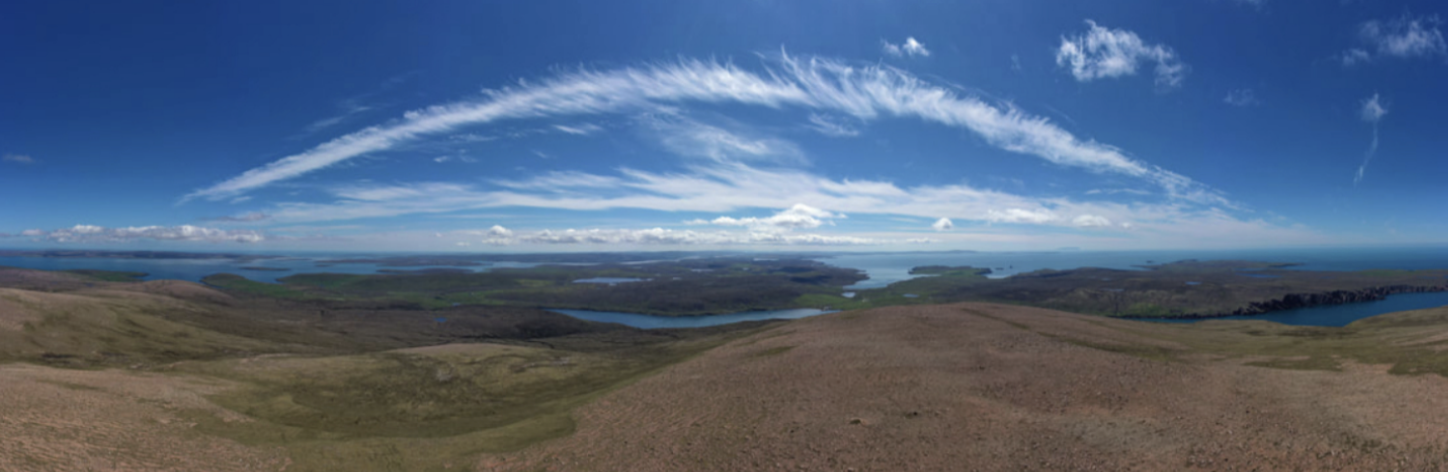
Ronas Hill rocky tundra. Photo courtesy of Southspear Media
The day was hot, and the walk was steep, but it didn’t take long to reach the top, at our leisurely rate we made it to the chambered cairn on the summit in an hour. From the peak, the views are breathtaking. To the north, we could see the dome on top of Saxa Vord Hill (on the most northerly part of Unst) and to the south, Fitful Head (the southern point of Shetland) that stood out on the horizon like a great sleeping dragon, snoozing in the summer sun. Every corner of the isles laid bare in front of us; the vista was spellbinding. We spent a bit of time at the top, catching our breath, eating homemade scotch eggs (thanks Shaun) and flying drones to get even more spectacular photos and video footage (for images and footage from the top, check out Southspear Media and Shetland by Drone on Facebook or Instagram, here and here).

Rona's Hill chambered cairn
Two features on top of Ronas are notable (other than the alpines), the geocache and the chambered cairn.
Geocaching in Shetland is a popular pastime, and they are found all over the landscape – basically, small Tupperware boxes containing trinkets and a visitor’s book are hidden and using GPS, people seek them out, leave a signature and something they may have in their pocket or rucksack.
The chambered cairn is an older structure, made from the weathered granite the structure dates to the Neolithic – about 5,000 years ago – and contains a large chamber inside. It has been added to over the years by climbers who place a rock to mark their achievement of reaching the summit of Shetland.
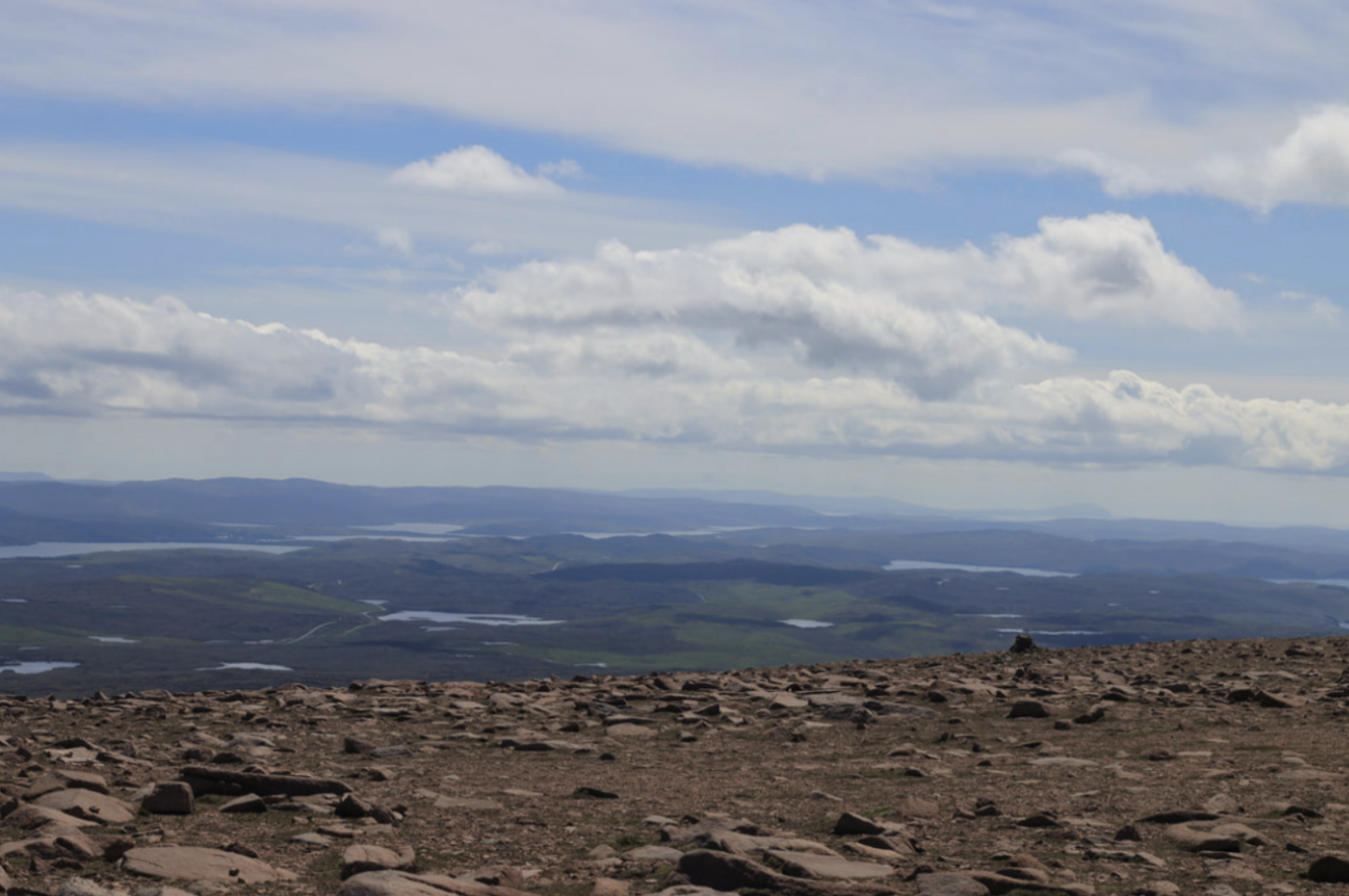
Views across Shetland from the top of Ronas Hill
Hunger satisfied and photos snapped we set off on the climb down to the Lang Ayre (Long Beach) on the other side of the hill. The downward climb was a lot easier on the legs, but you know what they say; everything that goes down, must come back up!
With the heat beating down on us, I stopped to fill my water bottle from the crystal clear burn, fed from springs deep inside the heart of the hill. The water was icy cold and refreshing, forced up through layers of granite before meeting the earth in a gurgling babble before winding its way through deep ravines down to the sea. ( A note of caution: take care when drinking from burns or streams, and only drink from a clean water source, make sure there are no dead sheep upstream!).

A long way down to the other side and the Lang Ayre

Route to the Lang Ayre
As we descended the hill, the bonxies (great skuas) began to circle above us, swooping stealthily in great circles overhead before landing again – scoping us out; a warning to us that we were in their territory.

Surveying remains in the landscape; trying to read the stones for clues about the past, Ronas Hill
Sweating less, I was able to reflect on the landscape around us. The area is barren and wild, yet there is evidence of people from the past all around. Just over the hill, at Grutwells, a Neolithic axe factory that produced highly polished felsite axes and knives that were exported all over Shetland by a prehistoric people. Halfway down the hill, built structures and field systems indicating lives lived here long, long ago – but the OS map and Canmore could offer up no indication of what these structures may have been, or who may have used them, and why.
Thinking about the people who inhabited these wild northern reaches, exposed to the elements and eking out a living in thin, unforgiving soils, I could only imagine what they may have thought about their Neolithic counterparts in Shetland’s lush and fertile South Mainland. They must have appeared to have had a very easy life in comparison to these northern people.

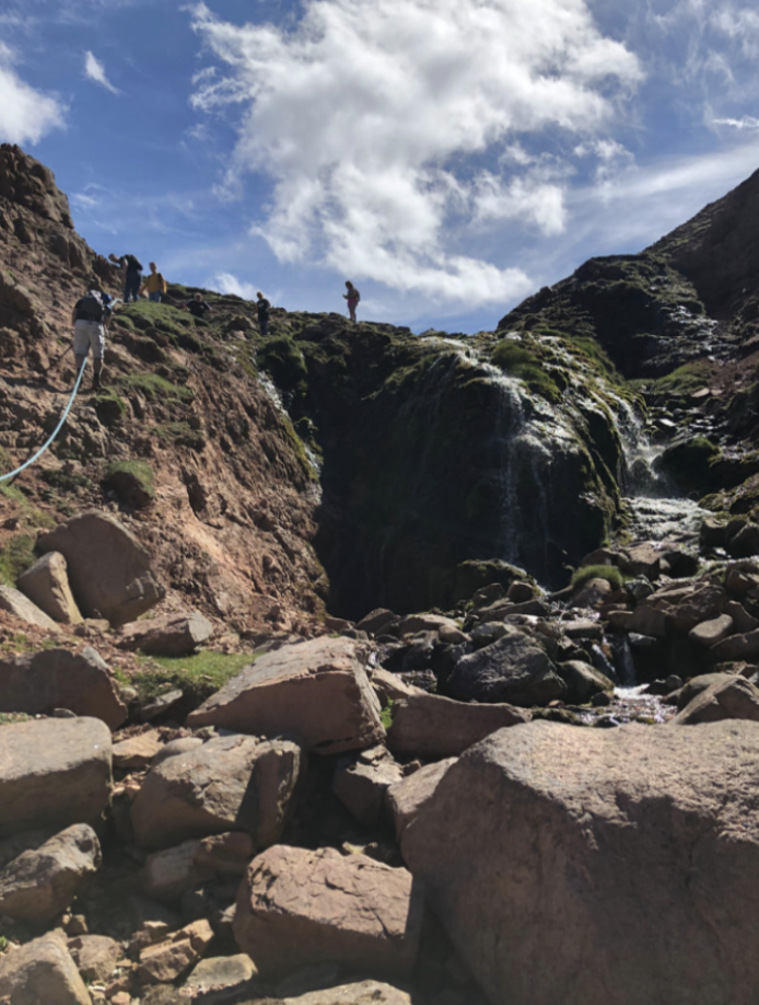
The route to the Lang Ayre, following the course of a burn down a steep ravine. Photo courtesy of Southspear Media
As the coast comes close, follow the deep ravine that terminates on to the red stones of the Red Ayre – this is the only way down on to the beach, and at the top of the cliff, there is a rope to aid your passage on to the beach below. This is a walk that would probably be inadvisable – if not unachievable – during the winter months.


The beautiful Lang Ayre. Photo courtesy of Southspear Media
The Lang Ayre itself is a veritable palette of colour; reds, oranges, greys and blues, all thrown together, rocks polished and smoothed in nature’s very own rock-tumbler. Each one placed and formed by the violent North Atlantic that ravages this impressive and imposing coastline. On the day we visited, it was calm, shimmering and still. A creel boat puttered around the stacks, hauling in creels; glistening jewels of water falling from burrop and buoy into the turquoise ocean below. Sitting, for a moment, by the water’s edge I listened as the sea washed over the stones, rushing in at haste before slowly making its retreat, water noisily finding its way around every pebble – sucking and gurgling as the power of the ocean pulls it back to sea. It was transfixing, the way it comes rushing in with such velocity, and pulled out again, almost reluctantly, clinging to every rock on its retreat.

The sea rushing up the beach; a transfixing sound on the Lang Ayre

The rugged coastline on Shetland's Atlantic seaboard
We lounged on the beach for a while, scoffing the rest of our picnics (and scotch eggs), marvelling over the beauty of the place. Words like, ‘Jurassic’ and ‘out-of-this-world’ banded around as we all struggled to absorb the sensory overload that fell before our sun-blinded eyes.

Our beachside views out to sea were spectacular at the Lang Ayre. Photo courtesy of Southspear Media
I was fascinated by the drone that Nick from Southspear Media was flying overhead (and I thank him for taking the time to give me the ‘idiots guide to drone flying’ lesson). We were able to see every inch of this remote and vast coastal landscape, fly between stacks and look back at our beachside seats from way out at sea. The whole experience was mesmerising, a reminder that technology can sometimes allow us to see a world in much more detail and clarity. It feels like a bit of an oxymoron to say that, as we often criticise technology for not allowing us to be ‘present’ in a moment; but to see the Lang Ayre from the vista of the fulmars and gannets that soared around us, felt to me, an incredible privilege. Although we all know someone who has lost a drone, right?

Incredible drone footage captured by Nick of the coastline at the Lang Ayre. Photo courtesy of Southspear Media
And then, just like that, it was time to leave and make our way back up the hill, back to our waiting cars on top of Collafirth Hill – just a 450-metre hike back. And as weary legs pulled us back up the way we had bounded down an hour or so before, we skirted the summit, avoiding the peak, before heading back down to our endpoint – back to the real world, away from the solitude and drama of Ronas Hill and the Lang Ayre.

Colours on the Lang Ayre
I think that on this sunny summer day I fell a little bit more in love with Shetland; a place that I feel coursing through my veins so deeply. There really is no better place in the world than home.
With love,

Finally, a massive thanks to Sophie and the gang for letting me join the walk and for the great company and laughs. And a special thanks to Nick from Southspear Media for letting me use the drone footage, and of course, Shaun for the homemade scotch eggs!

